The title more or less says what my query is about.
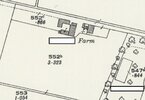
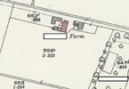
This concerns a detached ex-farmhouse on quite a big plot. I'll attach a couple of images below to show what it looks like (I've redacted some names for privacy).
I've really got no idea where to start with this. I would guess that the detached outbuildings were likely agricultural (maybe a barn or something) but I don't know what the attached outbuildings were.
Given that all the outbuildings were in existence in 1948 (they are shown on maps both from the 1920s and 1950s) how does this affect things? I don't know exactly when they were demolished but in was sometime between then and 1999.
Does the fact they were there in 1948 help us in any way? Or, as they've been demolished since then does that mean that we can't rely on them?
Also, I don't know if it's relevant but the property is just outside the settlement boundary for the village. The settlement boundary actually runs along the line of the trees shown on the map.
I've attached two images showing the original farm and the current building.
By the way, that isn't a road next to the house but it's the driveway of the property, the actual road and entrance to the property is off the map to the right.
Does anyone have any suggestions?


